This pages deals with global topography data sets on Earth up to a maximum spatial resolution of 1.8 km. If you need even higher resolution data please use for example the AppEEARS service from the USGS.
Global Topography Data
A key feature of Earth and other planets are its external (e.g. the surface) and internal (e.g. the Moho) boundaries. Salvus requires access to to this data in order to create a computational model of the planet.
Mondaic maintains an open-source tool SalvusTopo to create these files. Please have a look at the repository for more information and also if you are interested in creating your own files. It teaches you everything that is required. The files themselves are stored in NetCDF files following the CF convention.
Data Sources
Most of the downloadable files combine a number of freely available data sets. If you use it in a scientific context, please remember to cite the original data source, where appropriate. Files we offer on this page specifically utilize three external data sets:
Earth Gravitational Model 2008 (EGM2008)
https://en.wikipedia.org/wiki/Earth_Gravitational_Model
Specifically we use the Geoid undulations with respect to WGS84. In the
following we'll refer to this as Geoid.
Earth2014 global topography (relief) model
https://www.asg.ed.tum.de/iapg/forschung/topographie/earth2014/
Height in these is always relative to mean sea level.
Specifically we use two pieces of data: The spherical harmonics coefficients
for the Earth surface (referred to as Earth2014_SUR) and the for the Topo
bedrock, bathymetry, and ice (referred to as Earth2014_TBI).
CRUST1.0
https://igppweb.ucsd.edu/~gabi/crust1.html
We use CRUST1.0 to compute the position of the Moho boundary on Earth.
Specifically we use three pieces of data: The topography (referred to as
CRUST1.0_TOPO), the ocean (referred to as CRUST1.0_OCEAN), and the
crustal thickness (referred to as CRUST1.0_CRUSTAL_THICKNESS).
Preprocessed Data Sets for Download
The following data sets can be directly used by SalvusMesh to generate realistic Earth meshes. Please let us know if you'd like to see other data sets hosted. Aside from file size and data transfer concerns there is no penalty for using the higher resolution models as every file always contains the lower angular orders as well. What we mean by angular order is explained at the end of this page.
Global Topography Data Set
This data set combines the EGM2008 Geoid with surface data from Earth2014 to yield the absolute surface elevation relative to the WGS84 ellipsoid.
Topography = Geoid + Earth2014_TBI
| order | File Size | Download URL |
|---|---|---|
| 16-256 | 2.1 MB | topography_earth2014_egm2008_lmax_256.nc |
| 16-2048 | 116 MB | topography_earth2014_egm2008_lmax_2048.nc |
| 16-10800 | 2.6 GB | topography_earth2014_egm2008_lmax_10800.nc |
Global Bathymetry Data Set
This data set represents the bathymetry, e.g. the depth of the oceans. It is important that this data set is consistent with the used topography data set. You only need this if you intend to simulation an ocean layer either directly or via an effective ocean load.
Bathymetry = Earth2014_SUR - Earth2014_TBI
| order | File Size | Download URL |
|---|---|---|
| 16-256 | 1.6 MB | bathymetry_earth2014_lmax_256.nc |
| 16-2048 | 82 MB | bathymetry_earth2014_lmax_2048.nc |
| 16-10800 | 2.4 GB | bathymetry_earth2014_lmax_10800.nc |
Global Crustal Data Set
This data set represents the position of the Moho boundary on Earth computed as:
Moho Topography = Geoid + CRUST1.0_TOPO - CRUST_1.0_OCEAN - CRUST1.0_CRUSTAL_THICKNESS
| order | File Size | Download URL |
|---|---|---|
| 16-256 | 6.6 MB | moho_topography_crust_1_0_egm2008.nc |
Angular Order
To avoid spatial aliasing it is of crucial importance to use an appropriately filtered version for the chosen mesh. SalvusTopo internally represents models as spherical harmonics and can thus easily produce differently filtered versions depending on the maximum degree. In the following we'll refer to this as . Some interfaces in Salvus choose this automatically, some require you to make a choice. The maximum angular order approximately corresponds to spatial resolutions on Earth as given in the following table:
| Approximate equivalent spatial resolution on Earth's surface | |
|---|---|
| 16 | ~ 1250 km |
| 32 | ~ 625 km |
| 64 | ~ 310 km |
| 128 | ~ 155 km |
| 256 | ~ 80 km |
| 512 | ~ 40 km |
| 1024 | ~ 20 km |
| 2048 | ~ 10 km |
| 4096 | ~ 5 km |
| 10800 | ~ 1.8 km |
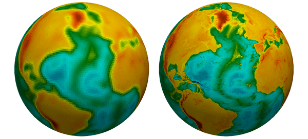
A single output file of SalvusTopo will typically contain a range of maximum angular orders. An advantage of using the CF convention is that the models can be readily visualized in Paraview:

This images demonstrates the difference between a global Earth surface topography model of degree 64 vs degree 1024.
 Mondaic