Simulating Marine Data for Distributed Acoustic Sensing (DAS)


Distributed Acoustic Sensing (DAS) is a novel data collection modality that measures the scattering of laser pulses traveling along fiber-optic cables buried within, or attached to the surface of, bulk objects. These scattering events can be used as a proxy for the axial strain along the cable, such as that imparted by propagating acoustic and/or elastic waves. The inferred strain measurements can then be used, for instance, to monitor the state of some subsurface resource (e.g. a geothermal field), to monitor the health of critical infrastructure, and, ultimately, to infer a time-dependent 3-D model of the bulk itself. Major advantages over traditional data collection modalities, which are primarily based on either inertial or piezoelectric point sensors, include the low cost of the fiber itself, its resilience in harsh environments and, perhaps most excitingly, its ability to use existing telecommunications infrastructure as a measurement device.
DAS deployments are commonly done on scales larger than those amenable to laboratory testing, and because of this scientists and engineers often turn to numerical simulations in order to understand the signals they record. Salvus allows for the simple and efficient simulation of acoustic and elastic waves in many scenarios commonly probed using DAS methods, and **natively supports the output of strain at arbitrary points, surfaces, and volumes**, which is critical when comparing to data. In this blog post we'll take a look at a specific scenario of interest to DAS practitioners: the simulation of seismic waves in the vicinity of the MARS cable deployed in Monterey Bay, California.
MARS DAS survey
The Monterey Accelerated Research System (MARS) cable is a 52-km-long fiber-optic cable connecting a subsea "science node", host to several different oceanographic experiments, to Moss Landing in Monterey Bay, California. Seismologists have recently become interested (Lindsey, 2019) in using the cable to record seismic events using principles based on DAS. The physical environment has the potential to be challenging to simulate. Factors such as:
- 3-D surface topography
- 3-D ocean bathymetry
- The fluid/solid interaction at the seafloor, and
- seismic reverberations in the ocean
all emerge to complicate the situation. Salvus, however, has the ability to automatically include all of these factors, and to produce an accurate and efficient synthetic dataset with minimal user effort and compute resources.
Topography and bathymetry
To deal with the complexities of Earth's surface, Mondaic hosts a few pre-processed topography and bathymetry datasets that are derived from several sources. These are valid for the entire globe, and interact natively with Salvus' bundled mesh generation software. **As a result, users can quickly generate geographically accurate meshes for any region on Earth**. Ocean layers, along with the ocean-subsurface coupling condition, are applied automatically. These datasets support topographic resolutions of up to 1.8km, and as such are sufficient for most applications in medium- to long-period seismology. If higher resolution topography is desired, Salvus can automatically download, read, and mesh it using the GMRT project's web interface. This feature, along with the usage of custom user-defined topography, will be explored in a future post.


Running a simulation


The animation below shows an onshore event acting as the source of a seismic wavefield in the vicinity of the MARS cable, with topography and bathymetry automatically extracted from the datasets described above. Immediately apparent is the smooth shoreline of Monterey Bay, and the presence of the fluid ocean (deep blue) in contrast to the onshore geography. As a source mechanism, a vertical force injected by a Ricker Wavelet -- one of several built-in source wavelets -- was chosen.
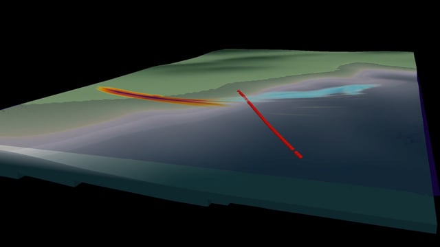
We see the elastic displacement (in orange / purple) at the surface as it propagates away from the hypocenter. As the wavefield enters the ocean, some energy is dumped into an oceanic reverberation, and a prominent Scholte wave is formed. This Scholte wave continues to propagate along the seafloor boundary, falling behind the elastic surface wave due to its slower speed. Looking at the shotgather below, we can also see these characteristics as they appear to the MARS cable. Plotted here, clockwise from top left, are the xx, yy, zz, and xy components of strain respectively. As the entire strain tensor is available for output at arbitrary point locations, rotations and transformations into different user-specified reference frames are a breeze.


The code required to setup the problem from scratch, run a 3-D simulation, output the quantities used in the animation, and visualize the strain output is completely described by a handful of Python cells in a Jupyter notebook. Input file generation and data collection is handled entirely by SalvusFlow, and no manual interaction with the compute resource is required. In all, **this 3-D simulation took a few minutes on a single NVIDIA GeForce RTX 2060 GPU**.
The example given in this post can be readily applied to any other region across the globe, and is not limited to the simulation of DAS data. The same flexibility we saw with strain measurements is available with elastic displacement, velocity, acceleration, or stress, or acoustic particle velocity or pressure, along with several other derived output quantities. For accuracy benchmarks, please see some comparisons with semi-analytic solutions, and always feel free to take a look at this open-access paper describing Salvus' design.
Benefits of Salvus for modeling DAS surveys
- Accurate placement of DAS lines in complex geometries.
- True solid-fluid multiphysics coupling.
- (Visco-)elastic / acoustic, with arbitrary elastic anisotropy.
- Performance and scalability in 2-D and 3-D on CPUs and GPUs.
- Modern Python-based user interface and extendable research platform.
